GEOTECHNICAL ENGINEERING
PORTLAOISE
HomeUnderground ExcavationsGeotechnical excavation monitoring

Geotechnical Excavation Monitoring in Portlaoise

Practical geotechnics, field-tested.

LEARN MORE

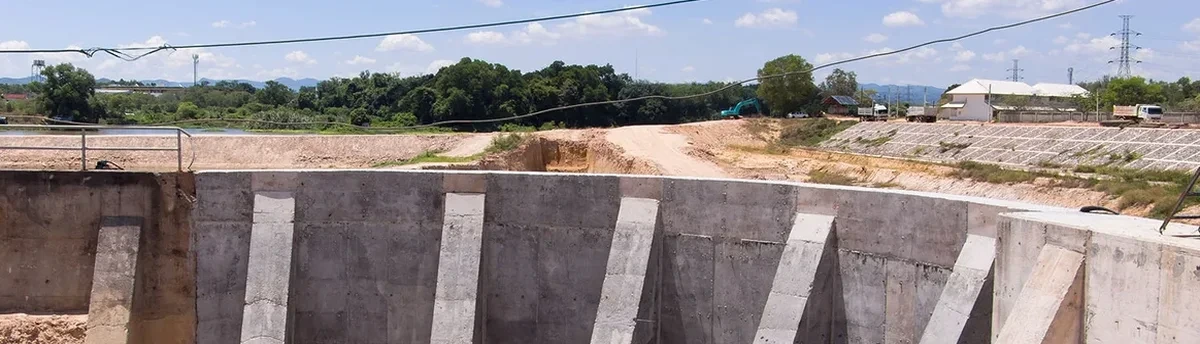
The sight of a total station set up on a tripod outside a Portlaoise town centre site, checking prism targets fixed to a steel sheet pile wall every two hours, is the first thing a visitor notices. That robotic instrument feeds coordinates into a laptop running monitoring software, comparing each reading against pre-set trigger levels tied to the shoring design. In the Triassic sandstone and dense glacial till that underlie much of the Laois county town, the ground can be deceptively stiff until water from the River Triogue or leaking services softens the interface between weathered rock and overburden.
We deploy a combination of manual and automated systems: shape accelerometer arrays inside inclinometer casing to detect lateral movement at depth, vibrating wire piezometers to track pore water pressure changes during dewatering, and surface settlement points referenced to a stable benchmark on the N80. For projects close to the historic courthouse or the railway line, integrating the deep excavation monitoring protocol with a real-time alert threshold ensures the contractor can react before movement reaches the serviceability limit state required under Eurocode 7 and the local planning conditions set by Laois County Council.

In Portlaoise glacial till, the switch from stiff overconsolidated clay to weathered sandstone can shift the failure mechanism from a wedge to a block slide; instrumentation must capture both modes.

Our service areas

How we work

All instrumentation programmes in Ireland must align with IS EN 1997-1:2005 incorporating National Annex NA, which governs limit state design for earthworks. In Portlaoise, the competent authority frequently asks for proof that monitoring covers both the temporary works phase and the post-construction consolidation period, especially where excavations exceed 4.5 metres in the dense boulder clay that blankets the M7 corridor. The weathered sandstone contact, typically encountered between 3 and 7 metres below James Fintan Lalor Avenue, creates a contrast in stiffness that concentrates shear strain at the interface. Our team pairs inclinometer readings with a CPT test profile to calibrate the soil model, because the undrained shear strength from cone resistance gives a direct input to the numerical analysis used to set the amber and red trigger values.
The data logger transmits via GSM to a cloud dashboard accessible to the resident engineer, the temporary works designer and the local authority. Key parameters monitored include lateral wall deflection, groundwater drawdown radius, vibration peaks during rock breaking, and tilt on utilities within the zone of influence. When excavation proceeds near St. Peter and Paul's Church or along the Triogue Linear Park, the council typically imposes a maximum horizontal displacement of 0.3% of excavation depth, measured every four hours during active digging.
Geotechnical Excavation Monitoring in Portlaoise
Technical reference — Portlaoise

Local ground factors

A four-storey hotel excavation on the Dublin Road ran into trouble when a pocket of loose silty sand, lensed within the till at 4 metres depth, collapsed into a sump hole after three days of dewatering. The sand had not been detected by the site investigation boreholes, which had been spaced at 25-metre centres. Because the contractor had installed a standpipe piezometer and an inclinometer in the retained cut, the monitoring log showed a 12 kPa pore pressure drop and a 6 mm horizontal kick at the wall mid-height 14 hours before the collapse. The resident engineer issued a stop-work order, backfilled the sump with granular material, and revised the dewatering sequence to a vacuum-assisted wellpoint system.
Without the instrumentation, the first sign of failure would have been a pavement crack on the adjacent bus stop layby. In Portlaoise, where the water table often sits within 2 metres of ground surface near the Triogue, the combination of a retaining wall monitoring array and a real-time piezometer network is not optional for any cut deeper than 3 metres; it is the only reliable way to manage the risk of a sudden loss of ground.

Need a geotechnical assessment?

Reply within 24h.

Email: contact@geotechnical-engineering.co

Regulatory framework

IS EN 1997-1:2005 + Irish National Annex (Eurocode 7: Geotechnical design), IS EN ISO 18674-1:2015 (Geotechnical monitoring by field instrumentation), CIRIA C760: Guidance on embedded retaining wall design, Specification for Highway Works (Ireland) Series 600: Earthworks

Technical data

ParameterTypical value
Inclinometer casing depth1.5x excavation depth, socketed into sandstone
Reading frequency during excavationEvery 4 hours via automated logger
Piezometer typeVibrating wire, grouted-in, 0.1 kPa resolution
Surface settlement point arrayLinear profiles at 5 m centres behind wall
Trigger levels (design approach)Green < 70% Sv; Amber 70-90%; Red > 90%
Reporting cadenceDaily summary + instant SMS alert on threshold breach
Instrumentation standardIS EN ISO 18674 series + CIRIA C760 guidance

Common questions

How much does geotechnical excavation monitoring cost for a typical Portlaoise site?

The monitoring package for a standard basement excavation with inclinometer, three piezometers and surface settlement points typically falls between €700 and €2,520, depending on the number of instruments, the duration of monitoring and the reporting frequency required by Laois County Council. A firm quote is issued after reviewing the temporary works design and the site-specific ground model.

What triggers a stop-work order on a monitored excavation?

Stop-work is triggered when any instrument reading reaches the red alert threshold defined in the monitoring plan, usually 90% of the design serviceability limit. The resident engineer receives an SMS immediately, and a technical note is issued within two hours recommending remedial measures such as reducing the unsupported cut height, increasing propping stiffness or modifying the dewatering rate.

Is monitoring required by the local authority for small excavations?

Laois County Council typically requires a monitoring plan for any excavation deeper than 3 metres or any cut within the zone of influence of a public road, utility or adjacent building. Even for a single-storey basement, if the retaining wall is within 5 metres of a neighbouring structure, a basic inclinometer and settlement array is usually conditioned in the planning grant.

Location and service area

We serve projects in Portlaoise and surrounding areas.

View larger map